Abstract
SCSU’s agricultural education depends on experiential learning – soil sampling, lab analysis, field observation – delivered not just to on-campus learners, but to a rural student population spread across the state. The Metaversity closes that distance: a partial photogrammetric twin of the Orangeburg campus, a complete building and facility directory, and a set of interactive agricultural labs, reachable from anywhere.
The platform’s scope broadened during delivery. What began as an immersive learning environment grew into a full interactive campus map and directory, covering every building and area on the grounds, with the immersive components seamlessly integrated.
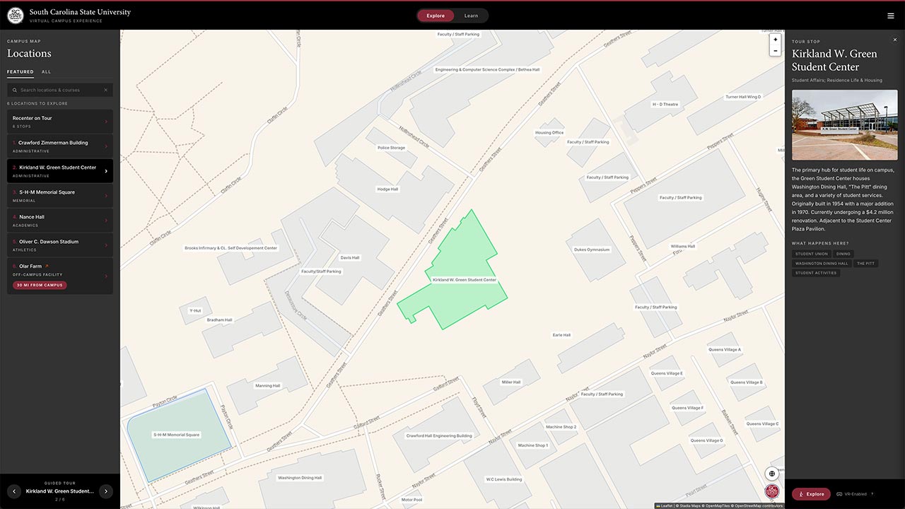
Fig 1. Ground-level capture puts students inside real campus locations. The guided tour lets users explore six featured locations, captured in real-time 3D using our photogrammetry pipeline.
Fig 2. The campus map indexes every building and area on the Orangeburg grounds, from academic halls to the machine shops, housing villages and parking lots. Selecting a footprint opens what the building holds: departments, facilities, what happens inside it, and the tour stops and course material attached to it. Buildings and boundaries are structured as GeoJSON, so the map and the directory are easily updatable at a single source.
Features
The discovery and requirements work came first, shaping everything after it: defined user groups, explorable areas and immersive material access were planned and mapped out long before any experience design took place.
| Capability | What it demonstrates |
| Photogrammetric campus twin | Buildings, interiors and landmarks captured from the real campus, so students recognise places before they arrive. |
| Complete building and area directory | Every facility on the grounds indexed and findable, with the map and the directory driven by one dataset. |
| Interactive agricultural labs | Soil, plant and animal health simulations students can repeat as often as the material requires. |
| Multi-device delivery | Browser and mobile for reach, Quest and Vision Pro for immersion, from one platform. |
| Blackboard integration | Progress and assessment results flow into the LMS the university already runs. |
| Compliance reporting | Usage and performance reporting structured for USDA-NRCS requirements. |
Fig 3. The soil sampling and diagnostics module runs as a sequence: site selection, sample collection and handling, diagnostic testing, then interpretation and reporting. Students work with reference material and demonstration footage available at each step, and can repeat the sequence as often as mastery requires.
Fig 4. Assessments follow each module and feed the student’s progress record. Results sync to Blackboard automatically, which is what makes the platform’s reporting usable for faculty tracking and for USDA-NRCS compliance without anything being re-entered by hand.
Conclusion
The Metaversity works because the campus acts as a light interface: a student looking for a soil lab can find it in a menu, or discover it in the building where it’s taught: immersive material reached through a place rather than a menu.
The same approach – capture the real environment, structure it as data, and use it as a framework for teaching material – extends to any learning institution, especially one with facilities students need to know but can’t always access.
Get In Touch
Ready to accelerate your transformation? Let’s start a conversation.